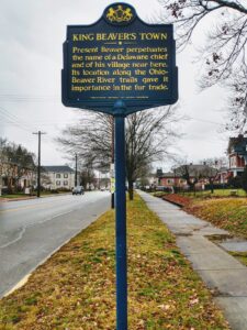
By the limits of Pennsylvania, as defined by the charter of Charles 2nd of England in 1681, the Indian ‘title’ lands were not recognized as extinguished by purchase until January 1785. This negotiation took place at Fort McIntosh where the town of Beaver now stands. Previously, in October, the Six Nations met with the Congress of the United States at Fort Stanwix, in New York, to demonstrate boundaries and limitations within the Ohio Valley region. These last purchases
constitute nearly a third part of the territory of the state itself; this also included the future counties of Lawrence, Mercer, Crawford, Venango, Clarion, Forest, Warren, McKean, Potter, Tioga, Clinton, Cameron, Elk, and large parts of Beaver.
Consequently, this is how the above-mentioned counties gradually acquired their shape. With surveyors employed by the government, they surveyed and numbered various tracts of land for the purpose of donation to Revolutionary War soldiers in exchange for their military service; the United States Congress had no money to pay them; instead, they were rewarded with plots of land.
However, these actions performed on Indian land did not come quietly. Many Indians were hostile to the white settlers and bloodshed was deep and wide across the entire Pennsylvania region.
In 1791, the Seneca Chief, Cornplanter, presented his dissatisfaction in a speech to General Washington: “Father; Your commissioners, when they drew the line which separated the land
then given up to you from that which you agreed should remain to be ours, did most
solemnly promise that we should be secured in the peaceable possession of the lands
which we inhabited east and north of that line. Does this ]u-onuse bind you?
Hear now, we beseech you, what has since happened concerning that land. On
the day in which we finished the treaty at Fort Stanwix, commissioners from Pennsyl-
vania told our chiefs that they had come there to purchase from us all the lauds belonging
to us within the lines of their State, and they told us that their line would strike the river
Susquehanna below Tioga branch. They then left us to consider of the bargain till the
next day; on the next day we let them know that we were unwilling to sell all the lands
within their State, and proposed to let them have a part of it, which we pointed out to
them on their map. They told us that they must have the whole; that it was already
ceded to them by the great King, at the time of making peace with you, and was their
o’wn; but they said that they would not take advantage of that, and were willing to pay
us for it after the manner of their ancestors. Our chiefs were unable to contend at that
time, and therefore they sold the lands up to the line, which was then shown to them as
the line of that State.”

In his reply to this complaint of one of the Six Nations, Gen. Washington
was careful to refrain from any promise of relief for the past, but only for the
future. He said:
“I am not uninformed that the Six Nations have been led into some difficulties, with
respect to the sale of their lands since the peace. But I must inform you that these evils
arose before the present government of the United States was established, when the sep-
arate States, and individuals under their authority, undertook to treat with the Indian
tribes respecting the sale of their lands. But the case is now entirely altered; the general
government, only has the power to treat with the Indian Nations, and any treaty formed
and held without its authority will not be binding.”
In their answer to this reply of Gen. Washington, Cornplanter and his
associates showed themselves to be no mean negotiators. They said:
“Father, your speech, written on the great paper, is tons like the first light of the morn-
ing to a sick man, whose pulse beats too strongly in his temples, and prevents him from
sleep. He sees it and rejoices, but he is not cured.
You say that you have spoken plainly on the great point; that you will protect us
in the land secured to us at Fort Stanwix, and that we have the right to sell or to refuse
to sell it. This is very good. But our nation complains that you compelled us at that
treaty to give up too much of our lands. We confess that our nation is bound by what
was there done; and acknowledging your power, we have now appealed to yourselves
against that treaty, as made while you were too angry with us, and, therefore, unreason-
able and unjust. To this you have given us no answer.
That treaty was not made with a single State; it was with the thirteen States. We
never would have given all that land to one State. We know it was before you had the
great authority, and, as you have more wisdom than the commissioners who forced us into
that treaty, we expect that you also have more regard for justice, and will now, at our
request, reconsider that treaty, and return to us a part of that land.
Father: The land which lies between the line running south from Lake Erie to the
boundary of Pennsylvania, as mentioned in the treaty at Fort Stanwix, and the eastern
boundary of the land which you sold, and the Senecas confirmed, to Pennsylvania, is
the land on which Half-Town and all his people live, with other chiefs, who always have
been, and still are, dissatisfied with the treaty at Fort Stanwix. They grew out of this
land, and their fathers’ fathers grew out of it, and they can not be persuaded to part with
it. We, therefore, entreat you to restore to us this little piece.”
To this Gen. Washington replied:
“While you complain of the treaty of Fort Stanwix, in 1784, you seem entirely to
forget that you yourselves, the Cornplanter, Half-Town, and Great Tree, with others
of your nation, confirmed, by the treaty at Fort Harmar, upon the Muskingum, so late as
the 9th of January, 1789, the boundary marked by the treaty at Fort Stanwix, and that, in
consideration thereof, you then received goods to a considerable amount.
To this the chiefs of the Six Nations made no reply, but in the negotia-
tions that followed in 1793, with the Indian tribes occupying the lands in the
present States of Ohio, Michigan, and Indiana, it was claimed that the only
equitable boundary between them and the whites was the Ohio River, of which
the Allegheny was then considered a part, as agreed upon by treaty with the
English at Fort Stanwix, in 1758, and that the treaties and sale of lands at
Fort Stanwix and McIntosh, in 1784 and 1785, were void, for the reason that
the Six Nations and Delawares, and Wyandots, were not the sole owners of these lands, which could only be disposed of by a general council of all the
Indian nations having rights therein. “
This position being finally taken by the Indians of the Northwest, the practical decision of the question of boundary was referred to the fortunes of war. In 1794 Gen. Wayne, by his decisive victory over the Indians at the Battle of the Fallen Timbers, entirely convinced them that the line of the Ohio
River was no longer a negotiable question, and by the treaty of Greenville, which he made with them in 1795, all their pretensions were given up, and
thus, after ten years of uncertainty, with alternate hostility and negotiation,
that part of the State lying north and west of the Allegheny and Ohio Rivers,
became the undisputed possession of Pennsylvania, and open for the occupa-
tion of white settlers. It’s difficult to study ourselves.

© 2024, admin. All rights reserved.


Helpful info. Lucky me I found your site unintentionally, and I’m surprised why this twist
of fate didn’t took place earlier! I bookmarked it.
Also visit my web site :: Nordvpn Coupons Inspiresensation
Wonderful blog! I found it while browsing on Yahoo News.
Do you have any suggestions on how to get listed in Yahoo News?
I’ve been trying for a while but I never seem to get there!
Many thanks
Also visit my homepage :: nordvpn coupons inspiresensation [92url.com]
This is the perfect webpage for anyone who really wants to find out about this topic.
You know a whole lot its almost tough to argue with you (not that I actually would want to…HaHa).
You certainly put a new spin on a topic that has been discussed for years.
Great stuff, just great!
Also visit my web site: nordvpn coupons inspiresensation
Nice blog! Is your theme custom made or did you download it
from somewhere? A design like yours with a few simple tweeks would
really make my blog jump out. Please let me know where you got your theme.
Kudos
Here is my homepage … nordvpn coupons inspiresensation (in.mt)
It’s appropriate time to make some plans for
the future and it is time to be happy. I’ve read this post and if
I could I wish to suggest you some interesting things or suggestions.
Maybe you could write next articles referring to
this article. I desire to read more things about it!
My webpage; nordvpn coupons inspiresensation
hello there and thank you for your info – I have certainly picked up anything new from
right here. I did however expertise a few technical issues using this site, as I experienced to reload the website a lot of
times previous to I could get it to load correctly. I had been wondering if your web hosting is OK?
Not that I’m complaining, but sluggish loading instances times will often affect your placement in google and
could damage your quality score if ads and marketing with Adwords.
Well I’m adding this RSS to my e-mail and can look out for much more of your
respective intriguing content. Ensure that you update this again soon.
Here is my web site: nordvpn coupons inspiresensation (tinyurl.com)
It’s nearly impossible to find educated people in this particular subject, but you seem like you know
what you’re talking about! Thanks
Feel free to surf to my homepage nordvpn Coupons inspiresensation
I like it whenever people get together and share opinions.
Great website, continue the good work!
Also visit my webpage Nordvpn Coupons Inspiresensation (Ur.Link)
My partner and I stumbled over here by a different web address and thought I should
check things out. I like what I see so now i’m following you.
Look forward to going over your web page for a second time.
Have a look at my web site nordvpn coupons inspiresensation
Hello to all, it’s actually a nice for me to visit this site, it consists of helpful Information.
Also visit my web-site :: nordvpn coupons inspiresensation